aesthetics making landscape urban space/place drifting rhythm memory nostalgia presence absence immediacy
Showing posts with label Mapping. Show all posts
Thursday, 18 November 2010
Yanko Tsvetkov: Mapping Stereotpyes
This links to the work of an illustrator/designer who maps the world in accordance with their stereotypical perceptions. Nobody is really left out, so it shouldn't be too insulting, although the Americans come out quite badly in a few of these examples as 'perpetrators' or maybe this is also a further stereotype? The image below is:
Monday, 25 October 2010
JR Carpenter: Cityfish [Click here]
Brilliant web space narrative by JR Carpenter, a digital mapping idea that makes an online narrative space come alive:
Tuesday, 24 November 2009
Time/Place.
When I was a small girl I was lucky enough to be brought up on a farm in Somerset, open fields were my own personal time and place. I used to go field walking with my Jack Russel Kandy, and we walk for what seemed miles looking for bits and pieces on the ground you could find all sorts of things for example, once I found a rusty pair of round victorian glasses with the glass still in, and this would send me off into another world because I would wonder what kind of person wore these. The open field can be like a time capsule in itself, and for me would be a valuable learning tool through my findings as an educational experience.
The Car Incident
Recently I did a project on situations, regarding a minor car incident I had recently. The meaning of `situation` refers to one's place and direction, relative to one's surrounding bearing location, orientation, position, the place where the thing is located, site, geography and the location of the phenomena such as other towns etc, the objective and set of conditions to which a person reacts.
I researched various types of Google maps that include ariel views showing the exact spot where the accident occurred. Then researched into a general form of geographical map that shows towns and villages with relation to the site itself.
Thursday, 19 November 2009
MAKING SENSE OF MAPS
Maps are used to convey information to the reader. In spaces we use maps to educate us, give sense of direction and orientation which make us feel more safe and secure. Without maps and direction we can get confused, even anxious and worried. On a journey it helps make sense of the place we want to get to.
Maps were mostly advanced and developed by the Greeks. In the 6th century Hecataeus (check hi
m out) drew the world and depicts it as an island with Greece as its’ centre. Hecataeus was a great geographer and philosopher and was highly thought of in his time.
It leads me to the question that maybe his map was fanciful and although he had a great knowledge from his travels he was only imagining or perceiving what the rest of the world looked like.
Maps help us visualise, anticipate, plan and read about what to expect. It fulfils and satisfies human emotions. It helps us focus and to see the way forward.
Imagine life without maps. Always wondering where we are and what is beyond the proximity that we are familiar with. It helps to identity the place you are in and the place you want to go.
Maps let us visualise a world around us. There is more in the information in the lines of the map than the words.
Today we take maps for granted. Maps have been used for thousands of years and here we see an old simple map where ‘X’ marks the spot.

Imagine life without maps. Always wondering where we are and what is beyond the proximity that we are familiar with. It helps to identity the place you are in and the place you want to go.
Maps let us visualise a world around us. There is more in the information in the lines of the map than the words.
Today we take maps for granted. Maps have been used for thousands of years and here we see an old simple map where ‘X’ marks the spot.

Maps were mostly advanced and developed by the Greeks. In the 6th century Hecataeus (check hi
m out) drew the world and depicts it as an island with Greece as its’ centre. Hecataeus was a great geographer and philosopher and was highly thought of in his time.Though Hecataeus was well travelled I am curious how his mind worked when composing this map.
How was he thinking when he perceived the oceans surrounded the land? Was the ocean to him as space is to us today? Was the ocean seen as infinity to the reader at that time bearing in mind that they did not know what was beyond this?
What made him think the continents were merged in this way?
It leads me to the question that maybe his map was fanciful and although he had a great knowledge from his travels he was only imagining or perceiving what the rest of the world looked like.
Wednesday, 18 November 2009
Mapping and Photography
I probably made my first connection between mapping and photography around the age of five. In this case, the mapping was not for my benefit but for my distraught parents. Faced with a rising five year old who could not be kept in the house, or indeed the neighbourhood, my father, a professional photographer, showed me how to use a simple camera and instructed me to take photographs during my travels. I realise now that this was his way of mapping my illicit journeys. All went well until he developed images of me several miles from home, happily making my way through the North Tyne canal with the local narrow boat community.
I've never looked back, almost literally, and have been walking the landscape ever since; I'm sixty-three now. I loathe being indoors and, contrary to what was said this morning, do all my daydreaming, reflection and contemplation in fields, moors and woodland, where I am most at home. I relate very little to other people, but often feel an instinctive, almost supernatural, connection with place and landscape. It's interesting to me that this morning's lecture brought up the idea of 'soul'; I think that this is what I try to find in my landscape images.
Given the restrictions of lens coverage, landscape photographers must always choose which part of a 360 degree vista to photograph. I do this by internalizing a mental map of the whole view and it is to this map that I turn for my choosing. My images are thus as much part of an internal landscape as an external one.
I am hoping that my Final Major Project later this year will be a book about 'Real Back Gardens' and will concern how people value and use the external spaces around their property. The back garden, rather than the front, is of interest to me because it has no public persona ; a bit like seeing someone before they put their makeup on.
It occurs to me that interesting research for this book might include mapping the ways in which people in a small neighbourhood use this space - drying washing, parking, refuse bins, wildlife, planting etc. It's a line of thought I'll be pursuing as a result of this morning's lecture amd seminar. Liz Rowett.
I've never looked back, almost literally, and have been walking the landscape ever since; I'm sixty-three now. I loathe being indoors and, contrary to what was said this morning, do all my daydreaming, reflection and contemplation in fields, moors and woodland, where I am most at home. I relate very little to other people, but often feel an instinctive, almost supernatural, connection with place and landscape. It's interesting to me that this morning's lecture brought up the idea of 'soul'; I think that this is what I try to find in my landscape images.
Given the restrictions of lens coverage, landscape photographers must always choose which part of a 360 degree vista to photograph. I do this by internalizing a mental map of the whole view and it is to this map that I turn for my choosing. My images are thus as much part of an internal landscape as an external one.
I am hoping that my Final Major Project later this year will be a book about 'Real Back Gardens' and will concern how people value and use the external spaces around their property. The back garden, rather than the front, is of interest to me because it has no public persona ; a bit like seeing someone before they put their makeup on.
It occurs to me that interesting research for this book might include mapping the ways in which people in a small neighbourhood use this space - drying washing, parking, refuse bins, wildlife, planting etc. It's a line of thought I'll be pursuing as a result of this morning's lecture amd seminar. Liz Rowett.
Janet Cardiff - The Missing Voice (1999)

Janet Cardiff uses maps of London to create her own tours which are a narrative through time and space. Maps are not used just for getting to a final destination but we use maps to navigate through spaces we are not familiar with. What happens in our mind while we are navigating through that space?
Janet Cardiff tries to relate to the listener a stream of consciousness scenarios that she invents in her mind while she walks through the streets. Starting at Whitechapel Library, visitors were given a Discman. You would leave the building and find yourself transported in time. What was that sound? Who is speaking to you? Where does reality end, and what’s imagined begin…?
ALSO CHECK OUT:
Richard Wentworth An area of outstanding unnatural beauty (2002)
AND:
Scanner (aka Robin Rimbauld) Surface noise (1998) - He lay the sheet music to 'London Bridge is falling down' over a map of the city. At the points where notes from the music fell across the map, Scanner took photos with a digital camera and recorded the sound that was happening at that point too, creating a 'soundtrack to a living city'.
Tuesday, 17 November 2009
QI - The world was never flat.
Going to try the html and hope that it works, but if that fails;
http://www.youtube.com/watch?v=TDXrpNk3fy4
Check out the link.
Because Stephen Fry is Always Right.
Spatial mapping using Axial maps
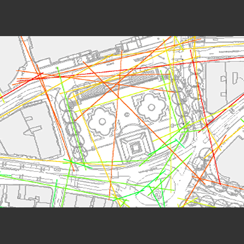
Axial maps sometimes referred to as Space Syntax is a system of mapping accessibility. It allows human behaviour, communication and interaction to be mapped in relation to Spatial layouts. It helps us understand how existing spaces are working and the potential effects of new interventions. The following images show some axial maps of Trafalgar Square when Norman Foster was asked to redesign it. They mapped different options and the best proposal was a central staircase leading from a newly pedestrianised area between the square and the National Gallery.


(images from http://www.lydiaheard.com/)
The following image from Google Earth shows how successful the space has been. As you can see its full of people.

Axial maps can show the impact of:
1. The street network on urban movement patterns and flows (Hillier and Iida, 2005),and the evolution of the local centres and sub-centres. (Hillier, 2006, 1999)
2. Spatial design on feelings of security and insecurity (Hillier 2004)
3. Urban Spatial segregation and social disadvantage (Vaughan et al 2005)
4. Spatial layouts on organisational cultures (Penn, 1999)
5. Office redesign on productivity (Bafna, 2005)
6. Museum layout on use and satisfaction (Stavroulaki and Peponis 2002, Hillier and Tzorzti 2007)
(Taken from http://www.udeworld.com/)


(images from http://www.lydiaheard.com/)
The following image from Google Earth shows how successful the space has been. As you can see its full of people.

Axial maps can show the impact of:
1. The street network on urban movement patterns and flows (Hillier and Iida, 2005),and the evolution of the local centres and sub-centres. (Hillier, 2006, 1999)
2. Spatial design on feelings of security and insecurity (Hillier 2004)
3. Urban Spatial segregation and social disadvantage (Vaughan et al 2005)
4. Spatial layouts on organisational cultures (Penn, 1999)
5. Office redesign on productivity (Bafna, 2005)
6. Museum layout on use and satisfaction (Stavroulaki and Peponis 2002, Hillier and Tzorzti 2007)
(Taken from http://www.udeworld.com/)
Thursday, 12 November 2009
Website Maps


Continuing on from yesterday, Web/Graphic designers plot out the website navigation using a simple form of sitemap, please refer to uploaded example. Basically this acts as an aid in the event of a problem with the linking of all the pages within the site. The plan is to have all the pages linking with each other but sometimes this can go wrong and the map is a paper version of the navigation you can refer back to, to help you re-establish those broken. This is not quite so crucial if the site only consists of a few pages, as it is fairly easy to backtrack and solve the problem. But say for instance you were building a site on the scale of Amazon, this map would be a life line in establishing any broken links.
Another form of sitemap is used by Google, Yahoo and other search engine providers. This is a page which is attached to the back end of your website, you provide a list of pages within the site and a link to each of the pages. When the site is submitted to say, Google for optimization ( Google crawls the site with their crawler Googlebot, which is searching for keywords and relevant information relating to your site, the more information it can find the further the site moves up the rankings) sometimes Googlebot doesn’t always crawl all the pages, as there could be missing or broken links. in this case if the sitemap page has been included, Googlebot will crawl this page seeking the information.
Both images are my own
skate park project in association with the life centre

For my external design project I have been researching infomation on the Life Centre that is being built in Central Park Plymouth. The skate park which is in the area now is going to be demolished and the area rebuilt on. At the moment this is the main park that skaters and bmx riders use the most. In my project I have been commissioned to design, using glass, a way that the concrete from the skate parks bowl can be recycled into 150 small awards and two large that will be given to the people that use the park. Before the park is torn down the bowl will be covered by an illustration by James Jarvis, a Londoner. This will be then carefully dismanteld (hopefully) so that it can then be combined with hot glass to create the awards.
Wednesday, 11 November 2009
UVW mapping within 3D Studio Max
UVW mapping is a mathematical technique used within 3D Studio Max(a game designing software) to convert a 2D image (a texture) to a 3D object. The easiest way to describe UVW is probably to think of the idea with flat World image drawn on the paper and then wrapped around a globe.The third dimension allows texture maps to wrap in complex ways onto irregular surfaces. Each point in a UVW map corresponds to a point on the surface of object. UVW mapping is commonly used to texture map non-platonic objects, non-geometric primitives, and other irregularly-shaped objects, such as characters, furniture, buildings etc.

The Use of Maps in Strategy Games
Strategy games are probably the best link between games and maps, as without them the game wouldn't be able to function.
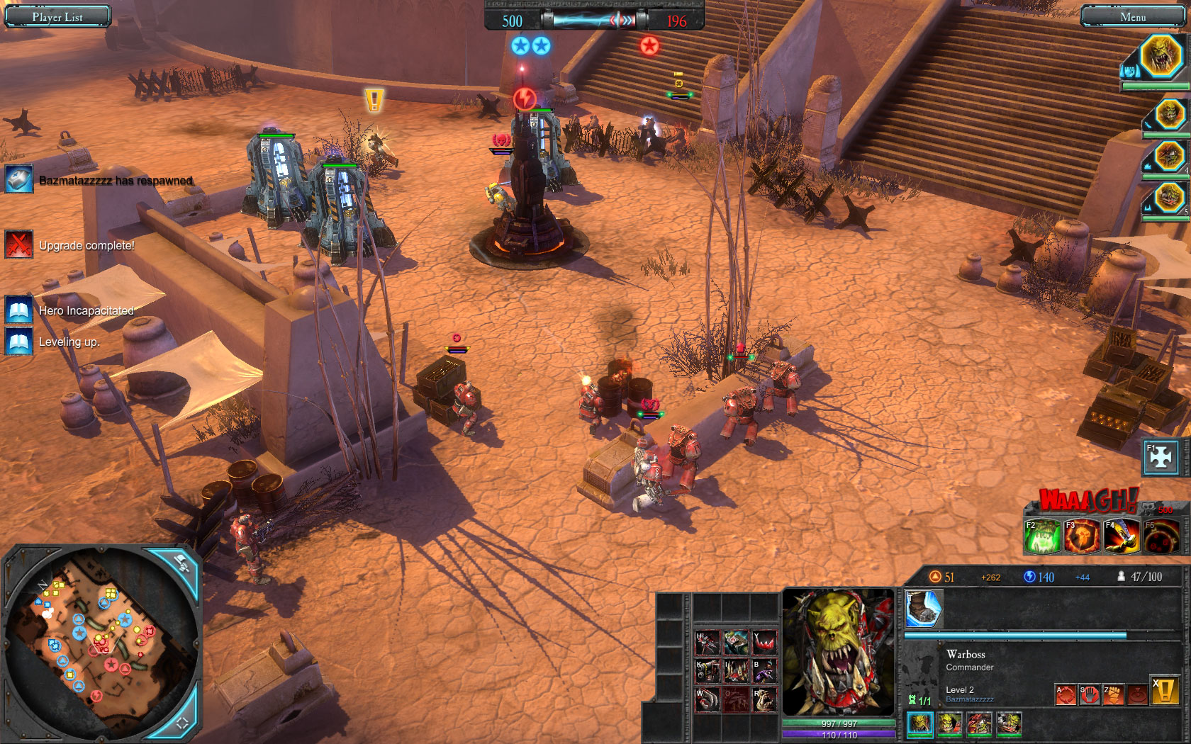
Real-time strategy (RTS) games are a type of wargame where the player controls units across a vast area in real time. These games use maps to display what is going on in the game, usually they also involve a minimap for a more tactical view, the maps can be zoomed in or out of to get a scale of the situation.
These maps change the very way the game is played, many RTS games use resources that are spent on units and buildings in the game, these resources are strategically placed so no side gets any sort of advantage. The map is usually also designed in a strategic fashion, creating choke points and open areas to create strategic situations for the player to overcome or use to their advantage.
However these maps are not only used in a strategic sense, many are beautfiully rendered containing masses of detail for example Relics' Dawn of War 2
Maps also play an integral part in games such as Sied Miers Civilization
This is a game where the player aims to ultimately take over the world by becoming one of historys great leaders, and changing how the world ultimately ends up. The player begins with one city, the civilization then spreads out creating new citys and towns, roads, mines, farms, everything you would expect to find on a real traditional map. In a way the maps evolve, as technology increases your map will change from that of a stone age prehistoric style hut through the times of the renaissance and finally to modern day sprawling technological hubs.
Real-time strategy (RTS) games are a type of wargame where the player controls units across a vast area in real time. These games use maps to display what is going on in the game, usually they also involve a minimap for a more tactical view, the maps can be zoomed in or out of to get a scale of the situation.
These maps change the very way the game is played, many RTS games use resources that are spent on units and buildings in the game, these resources are strategically placed so no side gets any sort of advantage. The map is usually also designed in a strategic fashion, creating choke points and open areas to create strategic situations for the player to overcome or use to their advantage.
However these maps are not only used in a strategic sense, many are beautfiully rendered containing masses of detail for example Relics' Dawn of War 2
Maps also play an integral part in games such as Sied Miers Civilization
This is a game where the player aims to ultimately take over the world by becoming one of historys great leaders, and changing how the world ultimately ends up. The player begins with one city, the civilization then spreads out creating new citys and towns, roads, mines, farms, everything you would expect to find on a real traditional map. In a way the maps evolve, as technology increases your map will change from that of a stone age prehistoric style hut through the times of the renaissance and finally to modern day sprawling technological hubs.
Sunday, 25 January 2009
mis-GUIDE
mis-GUIDE
On the subject of having to follow defined paths around places we visit I thought this would be relevant.
The idea, instead of setting out a set route from which to experience place, is to give starting points/ideas from which people can get off the routine path and see even familiar sights from a different perspective. Take a peak, break the boredom.
On the subject of having to follow defined paths around places we visit I thought this would be relevant.
The idea, instead of setting out a set route from which to experience place, is to give starting points/ideas from which people can get off the routine path and see even familiar sights from a different perspective. Take a peak, break the boredom.
Tuesday, 20 January 2009
The Strange Maps Blog
Just a quick link before I forget to post it at all.
The Strange Maps blog gathers together a unique selection of maps - some humourous, some artistic, but all interesting - which should prove useful to anyone looking to explore the concept of mapping further for their essay.
Session 2: Mapping and Territories
Following last weeks discussion on borders and identity, I started to look at fine artists that use mapping in their work. I came across Guillermo Kuitca, whose work is predominantly influenced by maps, landscapes, location and sometimes the represssive recent history of Argentina and his own childhood memories. This also brought me to the link that also included Amar Kanwar, whose work deals with the theme "borders", definitely worth a look.
Wednesday, 14 January 2009
Site Research

Within any design process research / mapping of the existing site is the starting point for all designers. Several factors have to be considered before creating new ideas, these include.
. Existing features
. Geometry of building, doors , windows.
. Scale and proportion
. Rhythm, repetitions
. Texture, exploring materials
. Light and shade
. Does it function well
. What will improve it
Monday, 12 January 2009
Mapping Radioactive Minerals
Radon is a natural radioactive gas. You cannot see, hear, feel or taste it. It comes from the minute amounts of uranium that occur naturally in all rocks and soils.Radon is present in all parts of the UK, although the gas disperses outdoors so levels are generally very low.
We all breathe it in throughout our lives - for most UK residents, radon accounts for half of their total annual radiation dosage. However, geological conditions in certain areas can lead to higher than average levels. Some of the highest radon levels have been found in the southwest, but levels well above average have been found in many other parts of the UK. Exposure to particularly high levels of radon may increase the risk of developing lung cancer.

Heartlands Project Cornwall
Of ecological and heritage interest, this a proposed theme park that celebrates the industrial archeology of Cornwall. Set within the ruins of industrial mining complex it charts the phenomena of the colonising of niche plant species that have emerged as a result of the conditions created by mining activity in the area.
Subscribe to:
Posts (Atom)